

West End of Lake Erie Flat Paper Chart 14830 (NOAA) 8/20/2025 THIS CHART IS IN STOCK 8/20/2025
SKU:
U-14830
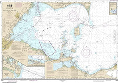
14830 West End of Lake Erie Flat Paper Chart
National Oceanic & Atmospheric Administration (NOAA) Flat Paper Chart
Size: 34" x 48"
Insets: Port Clinton and Monroe Harbor
- Not for navigational purposes.
- Printed on matte paper. Flat Paper Chart. Please note this chart is NOT laminated - the page is not appropriate for dry-erase markers.
- Scale 1:100,000
"8/20/2025 THIS CHART IS IN STOCK as of 8/20/2025"
OTHER PRODUCT
Other Product Picked For You


Sold out
Sale


Sold out
Sale


Sold out
Sale

Sold out
Sale

Sold out
Sale

Sold out
Sale
Sold out
Sale
Sold out
Sale

Sold out
Sale
