

The Thousand Islands Alexandria Bay, New York Waterproof Chart WP-78 3/26/2026 THIS CHART IS IN STOCK 3/26/2026
SKU:
WP-78
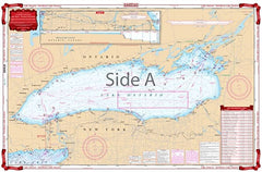
The Thousand Islands Alexandria Bay, New York Waterproof Chart WP-78
This chart is a combination of several government charts. From Wolfe Island, this chart covers the Clayton and Gananoque area east to Wellesley Island, Hill Island, and Alexandria Bay. Also, provides details of Clayton, Alexandria Bay.
The reverse side covers the seaway from Dingman Point, northeast to Brockville and Morristown, New York. Color key and large print place names make this chart exceptionally easy to use.
NOAA Charts: #14770, #14771, #14772, #14773, and #14774.
Nautical Chart is 25″ X 38″
"3/26/2026 THIS CHART IS IN STOCK as of 3/26/2026"
OTHER PRODUCT
Other Product Picked For You


Sold out
Sale


Sold out
Sale


Sold out
Sale

Sold out
Sale

Sold out
Sale

Sold out
Sale
Sold out
Sale
Sold out
Sale

Sold out
Sale
