

North East Lake Ontario to Kingston & Bateau Channel Waterproof Chart WP-141 1/20/2026 THIS PART IS IN STOCK 1/20/2026
SKU:
WP-141
North East Lake Ontario to Kingston & Bateau Channel Waterproof Chart WP141
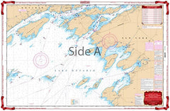
On Side one, this chart details coverage of the islands and channels between Kingston, Ontario, and Cape Vincent, New York, east to the Wolfe Island Cut. This chart also provides coverage of the Canadian Middle Channel and the Bateau Channel on the north side of Howe Isle.
The reverse side covers Kingston and Clayton in a smaller scale and provides a larger area, including all of Wolfe Island south to Stony Point and Henderson Harbor, and west to False Ducks Islands.
3 NOAA charts: #14768, #14767, and #14802
Chart is 25″ X 38″
1/20/2026 THIS PART IS IN STOCK 1/20/2026
OTHER PRODUCT
Other Product Picked For You


Sold out
Sale


Sold out
Sale


Sold out
Sale

Sold out
Sale

Sold out
Sale

Sold out
Sale
Sold out
Sale
Sold out
Sale

Sold out
Sale
