

Georgian Bay to Sault Ste Marie Waterproof Chart WP-177 8/20/2025 THIS BOOK IS IN STOCK 8/20/2025
SKU:
WP-177
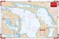
Georgian Bay to Sault Ste Marie Waterproof Chart WP177
This Waterproof Chart Side A includes the Straits of Macinac east to Lake Huron, north to St. Mary’s River and the North Channel, south to Saginaw Bay, and further east to the Georgian and Nottawasaga Bays.
A larger scale Inset of the De Tour Passage provides detail to begin your trip up the St. Mary’s river and points north.
This Waterproof Chart Side B begins at Whitfish Bay and continues through Sault Ste Marie (with Inset detail) along the St. Mary’s River to St. Joseph Island at Munuscong Lake where it joins Side A.
NOAA #14860, #14882, #14883, and #14884. Nautical Chart is 25″ X 38
"8/20/2025 THIS BOOK IS IN STOCK 8/20/2025"
OTHER PRODUCT
Other Product Picked For You


Sold out
Sale


Sold out
Sale


Sold out
Sale

Sold out
Sale

Sold out
Sale

Sold out
Sale
Sold out
Sale
Sold out
Sale

Sold out
Sale
