


Clayton & Alexandria Bay, NY Waterproof Chart WP-140
SKU:
WP-140
Clayton & Alexandria Bay, NY Waterproof Chart WP140
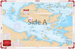
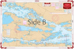
This chart provides detailed coverage of the heart of this very popular vacation and boating area. A combination of 3 government charts on one side provides a “close-up” view. Brightly colored shallows and marsh areas are easy to spot. GPS waypoints added.
The west side covers Clayton area with coverage from Wolfe Island Cut, east to Thousand Island Park and Fisher’s Landing, including all of Grindstone Island.
The east side covers the Alexandria Bay area, with Wellesley Island and the Canadian Middle Channel, east to the Summerland Island Group.
3 NOAA charts: #14772, #14773, and #14774
Nautical chart is 25″ X 38″
OTHER PRODUCT
Other Product Picked For You


Sold out
Sale


Sold out
Sale


Sold out
Sale

Sold out
Sale
Sold out
Sale

Sold out
Sale
Sold out
Sale
Sold out
Sale
Sold out
Sale
Sold out
Sale